Neighbors helping neighbors stay firesafe
Know Your Fire Zone
Stay Informed
FIRESAFE38.ORG
6/17/20262 min read

Understanding Evacuation Zones
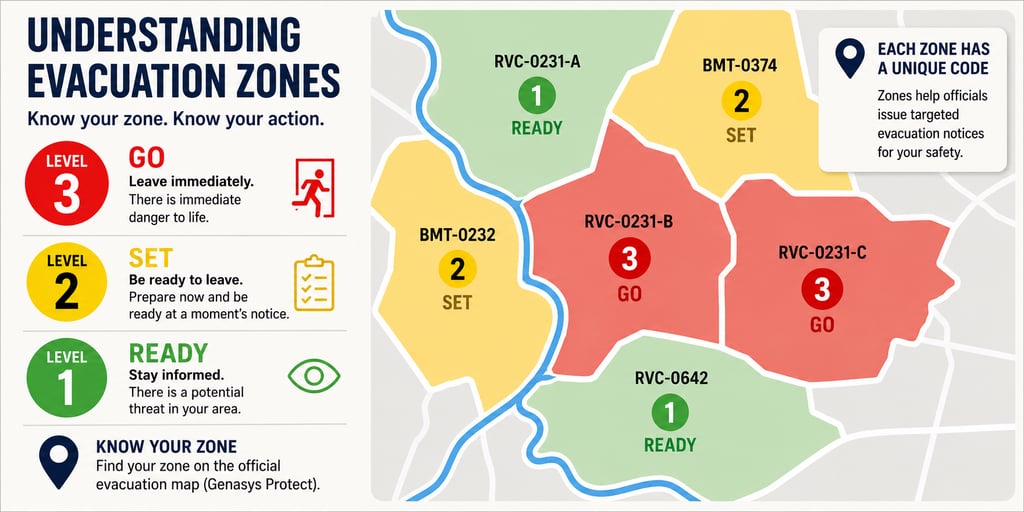
When a wildfire threatens an area, emergency officials divide the community into evacuation zones. These zones help emergency responders issue clear, targeted evacuation notices instead of asking an entire city or county to evacuate.
What is an Evacuation Zone?
Each zone is a specific geographic area assigned a unique identification code.
For example:
RVC-0231-B
RVC-0231-C
BMT-0378
These codes correspond to neighborhoods or defined sections of a community shown on the official evacuation map.
The letters at the beginning generally identify the local emergency management area or jurisdiction. The numbers identify the specific zone, and a letter at the end may indicate a subdivision of that zone.
Residents should learn their evacuation zone before an emergency occurs so they can quickly determine whether an evacuation notice applies to them.
The Three Evacuation Levels
🟢 Level 1 – READY
There is a potential threat.
Stay informed.
Review your evacuation plan.
Gather important documents and medications.
Prepare your vehicle and family if conditions worsen.
Not every wildfire will have a Level 1 notice.
🟡 Level 2 – SET
There is significant danger nearby.
Residents should be prepared to leave at a moment's notice.
This is the time to:
Pack your vehicle.
Load pets and livestock if possible.
Assist family members who may need extra time.
Stay off the roads unless necessary.
Continue monitoring official updates.
Do not wait until flames are visible.
🔴 Level 3 – GO
Leave immediately.
There is immediate danger to life.
Do not spend additional time gathering belongings.
Leave using the safest available route and follow directions from law enforcement or fire officials.
Why Some Zones Are Different
Wildfires rarely threaten every neighborhood equally.
One neighborhood may be under a GO order while the next neighborhood remains under a SET warning because:
the fire is moving in a different direction,
terrain influences fire spread,
firefighters have established containment lines, or
roads and evacuation routes differ.
Evacuation zones allow officials to move people safely while reducing traffic congestion and keeping evacuation routes open.
Know Your Zone Before You Need It
One of the most important things you can do before wildfire season is identify your evacuation zone and save it in your phone. During an emergency, officials issue evacuation notices by zone number, not always by neighborhood name. Knowing your zone can save valuable time when every minute matters.
Also learn the zones immediately adjacent to yours. If your zone is still at SET but the neighboring zone goes to GO, that's a strong signal to be ready for conditions to change quickly. It gives you a better understanding of what's happening around you, not just at your own address.
How to Find Your Zone
The easiest way to know your evacuation status is to locate your home on the official Genasys Protect evacuation map before an emergency occurs.
Once you know your zone number, you only need to watch for updates affecting that specific zone rather than searching through an entire list of communities.
Phone
place holder
© 2025 Mill Creek Canyon Fire Safe Council, DBA FireSafe38.org • Serving Forest Falls & Mountain Home Village
FOLLOW US